A stream or river is a natural, flowing waterway on the land’s surface. Stream channels are long, narrow depressions in the land where water flows. There are several common river channel types, also known as the major plan forms.
Before we dive in: If you’re an educator planning to teach about rivers, having great visuals to deepen understanding is key! I think you and your students will love my River Channel Materials, which you can also find within my complete Science on the River Unit (plus you’ll support my blog with your purchase! ❤️)
As a river flows from its headwaters out to the sea, it usually transitions between several different plan forms. The river channel is shaped by the surrounding landscape, underlying rock type(s), sediment availability, and flow regime (i.e., variation in the amount of water flowing through a river, including the magnitude and frequency of different size floods).

Different rivers naturally have different plan forms – and that’s a good thing! You will find healthy streams and rivers with various natural planforms – no one planform is necessarily better than the others. It is best for a river to be as close to its natural state as reasonably possible.
The major planforms are straight, meandering, braided, and anastomosing. Next, let’s take a look at the different types of river channels you may see:
Straight River Channels
Straight channels are seen in areas where the landscape is steep, such as mountains. The stream or river’s channel appears mostly straight with few curves or bends.

Meandering River Channels
A meander is a curve in a stream. Subsequently, a meandering river is curving with many noticeable bends or turns. Meandering channels are seen in areas where the topography is gentle or nearly flat, such as plains and valley bottoms. Even subtle changes in the land’s surface can shape the river’s path since water always flows downhill in the path of least resistance. Flow is fastest on the outside of a curve, causing erosion. In contrast, flow is the slowest on the inside of a curve. Sediments settle out of the water and accumulate on the insides of curves, where water flows slowest – forming point bars.

Notably, some meanders are curvy and nearly double back on themselves, forming a loop. These extra curvy meanders are called goosenecks. Over time, the fast waters on the outside curves of a gooseneck wear down the banks. Eventually, the curves erode all the way through so that the flowing river water bypasses the gooseneck, cutting off the loop. Then, the former gooseneck becomes a water feature known as an oxbow lake.


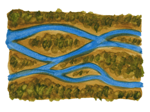
Braided River Channels
Braided channels are seen in many locations including deserts, plains, glacial outwash, and coastal areas. The river channel contains sediment bars, giving it a braided appearance. For a braided channel to form, there must be plenty of sediments available in the channel to build up bars. Bars can be made of a variety of sediments: silts and sands, gravels, or larger stones.
The locations and shapes of sediment bars change over time. Although the bars in a braided channel may look permanent, the sediment is slowly making its way downstream toward the ocean. The powerful, flowing water caries each grain of sediment a short distance at a time. In fact, a single piece of sediment may travel a short distance rapidly, then settle onto a bar or the riverbed for days, months, or even years before it moves again. Even so, large floods can cause rapid changes in the locations and appearances of the bars in a braided river.


Anastomosing River Channels
In an anastomosing channel, multiple river channels are separated by large, vegetated bars or islands. This gives the appearance of a few separate stream channels rather than one main channel. Braided rivers and anastomosing rivers are similar because they both have multiple channels that intertwine. The main difference between anastomosing rivers and braided rivers is that the channels of an anastomosing river are separated by semi-permanent islands, while the sediment bars of a braided river are more ephemeral.
Teaching Rivers in Your Classroom
Are you an educator planning to teach about rivers? You can save time preparing lessons by using my complete Science on the River Unit below. Plus, you’ll support Wild Earth Lab with your purchase!

Are you interested in reading more posts like this? Subscribe or follow Wild Earth Lab using the links below!
References and Further Reading
- National Park Service (n.d.). Fluvial Features: Meandering Streams. Available: https://www.nps.gov/articles/meandering-stream.htm
- National Park Service (n.d.). Fluvial Features: Braided Streams. Available: https://www.nps.gov/articles/braided-stream.htm
- Plummer, C. C., Carlson, D. H., & Hammersley L. (2019) Physical Geology. New York, NY: McGraw-Hill Education. (16th ed., ch. 10).
2 replies on “River channel types: identify straight, meandering, braided, and anastomosing channels”
[…] kan zijn van elk van deze drie vormen. Een laagdrempelige beschrijving van de vier begrippen is hier te […]
[…] separated by long-lived vegetated islands. Geomorphologists classify this type of channel as anastomosing. The OLI (Operational Land Imager) on Landsat 8 acquired the image on August 16, 2023, one of the […]